The ‘Secret Garden’, Styal Country Park, Wilmslow
by Fred Owen
Quarry Bank House, the original home of mill owner, Samuel Greg, was acquired from its private owner by the National Trust in November 2006. The house is located in fine gardens adjacent to the well known Quarry Bank Mill in the River Bollin sandstone gorge. The garden, now known as the ‘Secret Garden’, is endowed with quite exceptional Permo-Triassic outcrops featuring splendid examples of sedimentary and structural features, never accessible to the public before.
At the request of the NT, during the latter half of 2007 Fred Broadhurst and I prepared a geological handout for visitors to the Secret Garden, which was formally opened to the public in March 2008. Since then we have joined in conducting a number of walks round the gardens for the public with the head gardener. The public response has been extraordinarily positive; many visitors expressing amazement at how much information can be deduced from rocks previously regarded as insignificant! We have also led walks for geological groups with similar expressions of interest.
This article gives a brief summary of some of the features in the Secret Garden, extracted from the information presented for the handout. (Note: we gave two descriptions –one jargon free and one for geologically-literate visitors!)
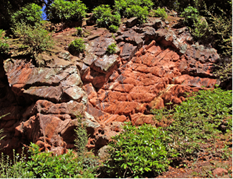
Figure 1 rich pinkish-red sandstone around the grotto
Rich, pinkish-red sandstone in the rock face around the grotto (figure 1)
The quartz grains are coated with the ferric oxide haematite, formed by the breakdown of mafic minerals in an arid, oxidising environment which episodically experiences heavy rainfall. The pore spaces between grains allow fluids to pass through the rock. If the fluids are reducing agents, like hydrocarbons such as methane, oil, and possibly hydrogen sulphide are, the haematite is reduced to other ferrous compounds and the red colouration is removed. In the past this variation in colour was referred to as ‘mottled’.
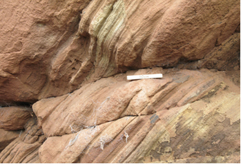
Figure 2 over-steepened lee slope of the sand dune
Steeply sloping layers (figure 2)
As you look at the quarry face the thin layers slope at a steep angle from top right to lower left. These were formed in arid, desert conditions and represent the downwind slope of a fossil sand dune. In this case the wind was blowing from right to left.
When free-flowing particles form a pile they make a natural angle with the horizontal called the ‘angle of repose’. For sand grains this is around 25 to 30 degrees. In dry, arid conditions the wind picks up the smaller grains and deposits them on the lee of the dune, while the windward slope is continually eroded. In this case the angle of cross-bedding occurs at 49 degrees and is much greater than expected because the beds have been tilted by subsequent earth movements in the same orientation as in figure 3.
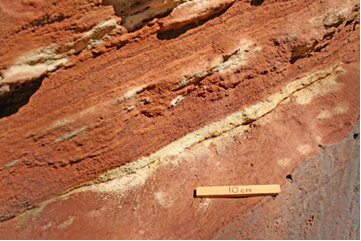
Figure 3 the regional tectonic dip
Gently sloping layers to the left (west) of the sand dune (figure 3)
The laminated beds slope at the regional tectonic dip of 23 degrees to 100 degrees west, representing the dip of the western limb of the Wilmslow Anticline, which has a NNE-SSW axis. It is this additional dip in the same sense that has over-steepened the lee slope of the fossil sand dune.
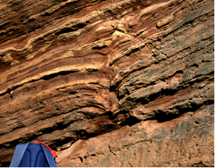
Figure 4 dewatering structures in the laminated sandstone
Distortions in the sand layers (figure 4)
These sediments were deposited under flowing water. Seismic activity separated the water from the sand and the density contrast forced the water upwards deforming the laminations to give the way-up and forming the dewatering structures shown.
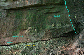
Figure 5 an example of several faults
Displaced and jumbled up layers (figure 5)
East-west tensional tectonic forces have created a series of N-S pull-apart faults throughout
Cheshire and these are examples of them. They appear to be normal faults with minor strike-slip movement.
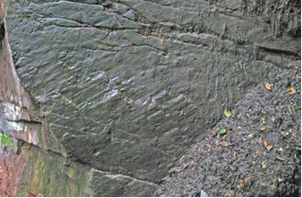
Figure 6 slickensides showing a sinistral fault
Scratch marks on a smooth, flat, vertical surface (figure 6)
When looking at the fault plane the slickensides and plucking marks indicate that the far side has moved to the left relative to the near side, so this is a sinistral fault.
How did this landscape form?
The red sandstone was formed in the Triassic Period, 238 to 205 million years ago. At that time Cheshire was situated about 20 degrees north of the equator, roughly equivalent to the location of the Sahara Desert today. Being in the tropics, the climate would be arid with sporadic downpours. During drought periods the wind would form sand dunes. At other times flash floods and fast flowing water would carve a network of river channels (flashes) into the
sediments. Sands, silts and clays would be deposited in the channels as the floods subsided. Water pools, or lagoons, remaining after rain may subsequently have had sand blown into them. This sand would settle to be included in the bottom deposits of silt and clay. This combination of climatic conditions, and an abundant supply of sediment, formed the red rock succession seen today.
Earthquakes probably caused the development of the dewatering structures in the wet sediments.
Subsidence eventually resulted in the burial and compaction of the Triassic rocks by at least 2 km of overlying rock. Subsequent earth movements have deformed the rocks by the development of faults and folds, for example the Wilmslow Anticline.
The red rocks have been uplifted to their present position by relatively recent earth movements, probably related to the opening of the Atlantic Ocean.
The River Bollin has cut through the sandstone in the gorge to expose the red sandstone in several places in Styal Country Park. This sandstone has been used to build the Mill. We are fortunate to have such brilliant examples of the past geology in the Quarry Bank House Gardens to see evidence of an ancient desert landscape.
Take a visit to the Secret Garden, combine it with a walk round the Styal Country Park Geology Trail and finish off with a coffee in the café. You will not be disappointed!
**************************************